- Gumption Savannah Newsletter
- Posts
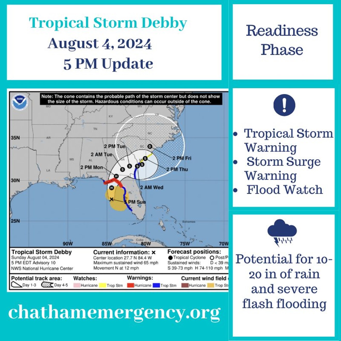
- Savannah closures, shelter information, Flood prone areas & The city offices are closed todayt
Savannah closures, shelter information, Flood prone areas & The city offices are closed todayt
Street flooding is currently widespread throughout the City, and while multiple street closures are occurring, extreme caution should be used when driving through the City.
Jay Paszamant
August 06, 2024 • Estimated Reading Time: 5 minutes

Good morning, Savannah!
In today’s newsletter:
Savannah closures, shelter information
Flood prone areas
The city offices are closed today
Let’s get to it.
-Jay Paszamant
SAVANNAH CLOSURES, SHELTER INFORMATION
Due to impacts from Tropical Storm Debby, the City of Savannah has designated the Enmarket Arena as an emergency shelter for residents without shelter. City staff is coordinating with the American Red Cross to open the shelter at 8 p.m. Residents are encouraged to use the shelter only if absolutely necessary, as capacity is limited.
The Tompkins Regional Center was opened as an emergency shelter for individuals experiencing homelessness and reached capacity around 7 p.m. On Monday, the City of Savannah’s partners at Chatham Savannah Authority for the Homeless (CSAH) coordinated shelters for the homeless population. As of 4:30 p.m., all traditional shelters and Come as You Are Ministries had reached capacity.
Street flooding is currently widespread throughout the City, and while multiple street closures are occurring, extreme caution should be used when driving through the City. For the latest map of flood-prone areas and current road closures in the City, visit savannahga.gov/debby.
As of 8 p.m., the City has closed the following streets to traffic:
Tremont Road from Ogeechee to Dodge
Anderson St. from Atlantic Ave. to Ott St.
Henry St. from Atlantic Ave. to East Broad
Paulsen St. at Park Ave.
Victory at Cedar Ave.
Victory at MLK
Brightwood at Margatha
W. 48 St. from Stanley to Hopkins
The City anticipates additional closures of the following streets:
52nd from Montgomery to Exchange
51st from Hopkins to Stevens
Anderson at Paulsen
Paulsen from 63rd to 60th
Victory at MLK
E. Lathrop at Louisville
Jefferson from 38th to 39th
Abercorn from 63rd to 66th
Grove from Anderson to 31st
Newell from Lathrop to Glass
Magazine from Feeley to Cornwall
Ferrill from Exley to Bay
Habersham from Columbus Lane to 63rd
Jefferson at 34th
60th from Reynolds to Battey
37th at MLK
Thackery from Sylvan to Oakview
Updates will be made at savannahga.gov/floodalert.
Savannah residents and businesses are urged to review emergency plans and kits ahead of the arrival of inclement weather. Information on preparedness can be found at ready.gov/hurricane.
CLOSURES
Here is a partial list of closures that have been announced due to Tropical Storm Debby:
Curfew: As reported, there is a citywide curfew in Savannah from 10 p.m. on Monday until 6 a.m. on Tuesday.
Savannah-Chatham County Public School System: Schools are closed on Tuesday, Aug. 6 and Wednesday, Aug. 7 for students and staff; no remote learning.
City of Savannah Government: On Tuesday, Aug. 6, a number of buildings and non-essential operations will be impacted or suspended. For the complete list, click here.
Chatham Area Transit: CAT service is suspended on Tuesday, Aug. 6 and Wednesday, Aug. 7.
Savannah State University: Operations are suspended on Monday, Aug. 5, and Tuesday, Aug. 6. Events are canceled from Monday, Aug. 5, through Wednesday, Aug. 7. For more information, click here. Sign up for Savannah State University emergency alerts here.
Savannah College of Art and Design: Virtual learning begins Monday, Aug. 5; all buildings in Savannah are closed on Tuesday, Aug. 6. See full statement below:
"SCAD is actively monitoring the path of Tropical Storm Debby. The university’s top concern is the safety and wellbeing of its students, faculty, staff, and their families.
LOCAL WEATHER
Today - 🌦️ Rain and possibly a thunderstorm. Some of the storms could produce heavy rainfall. 🌡️ High near 81. 🍃🍃Windy, with an east wind 21 to 28 mph, with gusts as high as 40 mph. The chance of precipitation is 100%. New rainfall amounts between 2 and 3 inches possible.
Tonight - 🌦️ Rain and possibly a thunderstorm. Some of the storms could produce heavy rainfall. 🌡️ Low around 75. 🍃🍃Breezy, with a northwest wind 18 to 21 mph, with gusts as high as 32 mph. The chance of precipitation is 100%. New rainfall amounts between 1 and 2 inches possible.
QUOTE OF THE DAY
Great necessities call out great virtues.
THE DIGEST
WHAT’S HAPPENING
Due to Tropical Storm Debby, all events for the next few days have been canceled or postponed. Once we get news, we will share those updates with you.
EXTRA NUGGETS

How did we do on today's newsletter?Share your feedback with us... |
✏️️ Want to write an article for us? Send us an email.
Want your business featured in our newsletter? Learn more about advertising opportunities.
We appreciate our readers. If you enjoy today’s newsletter, please share it with a friend, family member, or co-worker.
Reply